PNGAA Library
Exploring the Jimi Valley: Paul Ryan
![]()
In the late 1960s it seemed as though the valley of the Jimi River had been forgotten; a small part of Papua New Guinea largely passed over in the development process and progression into the modern world. Located on the northern fringes of the Western Highlands, where considerable outside investment had been made since the early 1950s, the people of the Jimi Valley were stuck in an otherwise bygone era. There were no roads into or in the valley and no towns, with the people living in small villages on the higher ground, where there was less chance of suffering from malaria. It was only a matter of a few years since the people had first made contact with ‘white men’. General administration as well as law and order was undertaken by a patrol officer who was based at Tabibuga patrol post, situated on a ridge at the eastern end of the valley. This was served by light planes landing at an airstrip carved into the side of the ridge and only approachable in one direction.
The people of the Jimi Valley were really not far removed from the stone age, having acquired steel axes and knives only in the last decade and, as we found, were still without files to sharpen such implements, in many cases. In fact, the area was well known for its stone axes; both the shorter, better balanced utility axe, which was actually used for chopping, and the more ornate and counterbalanced ceremonial axe, which was used for compensation and as part of a bride price.
At a later date, during our timber inventory of the Valley, we acquired several of these latter type axes. Our first Minister of Forests, Siwi Karundo, a man from Chimbu, in the Highlands, happened to be visiting our base camp, and so we asked him the worth of these axes. He thought for a moment, then said, in tok pidgin, "if you had twelve of such axes, plus about twenty mother of pearl shell, plus fifteen pigs, it would be enough to purchase a bride like that", and pointed to the Playboy centre fold for Miss March we had pinned to the wall.
In 1968 the Forestry Department decided that the forest resources in the Jimi Valley should be acquired for potential logging operations. Apparently, this decision came about because the Director of Forests at the time was flying over the valley, en-route from Madang on the north coast when he noted that there were quantities of Araucaria (Klinkii) pine present, a species that was quite valued for use in plywood. The timber rights purchase was then carried out, with considerable sums of money being flown in by helicopter and light plane and paid out to the locals, who really had no idea of the value of their resource and very little concept of the value of the money with which they were being paid. Their main concern was that the money be in coin, not paper notes, as the latter tended to deteriorate quickly when kept in the village. The down payment for the timber rights given to these people by the government some months earlier amounted to approximately Australian $80,000. However, it really only represented a fraction of the royalty that should have been paid to the landowners for their trees when such trees were eventually cut.
So it was that I found myself and Bob McKeowen, a friend and draftsman, being deposited by helicopter on a rocky bend in the Jimi River around mid-1968. The Department had decided that, having bought the timber rights, they had better find out the extent and nature of the resource. I was to eventually manage the inventory of the forests there. However, we first had to decide how we would tackle the job, given the fact that we had to assess both the Araucaria (klinkii pine) and other merchantable species in the forest; obtaining a sample that would give a reasonable estimate of the volume of both sorts of trees.
We set up our tent fly in thick forest near the Jimi River and set out for a quick recce of the nearby area. Not far from our camp site we came across what appeared to be a road in the middle of this jungle. This wasn’t just scrub, it was high forest, and trees up to 70 centimetres diameter and 40 metres high had been felled to create a 20 metre wide swath for a right-of-way over several kilometres, and a basic road form had then been constructed, entirely by hand. You could have driven a Landrover down it, at least to the nearest decent water course. They hadn’t mastered the art of building road bridges so there were no bridges. On the other hand, the local people were very adept at building cane bridges across quite wide waterways and it was quite an experience to negotiate one’s way across this wildly swinging structure on a narrow footing of bamboo while clinging to the rattan cables and trying to avoid being mesmerized by the rushing river some 20 meters below.
At our camp site we were soon joined by some of the local inhabitants who were quite interested in what we were doing. We managed to explain this to them through a mixture of tok pidgin and gestures. Then we asked them about the road and gathered from them that it was built by the local villagers so ‘that the cargo could come’ and it extended most of the way down the valley, a distance of about twenty kilometres.
Having finished our conversation, the villagers just sat on their heels and watched us with a quiet curiosity, as we unpacked and set up our beds. Dinner was started before dark so that we could see what we were doing and we had a wonderful meal, while sitting on the stones of the riverbed. Everything is relative, of course, and it certainly wasn’t high-class cuisine. But for the bush it was great. First off was a sherry or two out of the same mug from which we then had some soup and finally Milo after downing tinned stew and rice. The villagers pounced on any empty tins with glee, examining them with great interest, and then carrying them off for heavens knows what purpose.
Next morning the villagers were back again and asked if we had any files to sharpen their knives and axes. After some vigorous sharpening had taken place, they then proceeded to delightedly chop down a few medium sized trees in the vicinity to test the axes renewed cutting potential, regardless of where the trees fell. They offered to sell us fruit and vegetables, but when we asked about prices, it became obvious they had little knowledge of the value of the currency. So we agreed on some reasonable prices and proceeded to get a good store of fresh food to supplement our tinned diet.
Our work in the valley consisted of walking over as much of the area as possible to see how the forests were structured. As with a lot of lowland and mid-montane forests in PNG, they were not virgin or climax forests, but rather advanced secondary forest. This was the result of shifting cultivation by the local forest dwellers, who had cut the patches of the forest down, possibly on a rotation of about 40 years, to plant their food gardens. However, some species, such as the Klinkii Pine and the denser or harder wood species were not felled during the shifting cultivation process and could be up to 300 or 400 years old.
During the subsequent inventory we saw graphic evidence of this cutting and regeneration of the forest in the trunk of a Klinkii Pine we had felled to test for defect and decay. The tree had its branches pruned when other trees grow beside it as do many species. However, when the surrounding trees are felled, shoots would then develop into new branches and this happened every time some local cultivator cleared the forest to make a vegie garden. What we saw in the ‘biscuit’ cut from the log several metres from the butt were branch stubs imbedded at different depths in the log. This provided a record of the dynamics of the forest surrounding this particular tree. It showed that, on average, clearings, presumably for crop gardens, had been made about every 40 years on about four or five occasions. The locals told us the pine was allowed to stand because it was believed to harbour the ghosts (masalai) of departed relatives.
The people were very short, almost pygmies, not being above five feet tall, and were dressed largely in clothes made from bush materials. For the men this consisted of a smooth bark belt into which was tucked a bunch of leaves over the rear end and a bunch of grass over the front. The women were dressed in a similar fashion, being bare breasted. A few individuals had pieces of western clothing, such as a shirt or shorts. Nobody wore anything on their feet. They were, generally, very friendly and prepared to help us as much as they could. From discussions with them and from the local patrol officer, we learnt that they had had a rough time of it over past generations and even today. Malaria had been rampant in the past and was still a major problem, particularly in the lower lying areas of the valley. It had affected the population to such an extent that their numbers had been significantly reduced, possibly halved. By the 60s, despite the development that had occurred in the country, they had a difficult existence, being remote from any medical assistance as well as from ready access to goods or markets for any saleable products. They had only limited communication with the rest of PNG and virtually no communication with the rest of the world. Apart from the few modern tools they may have acquired from some distant trade store, their existence, as subsistence farmers and food gatherers, was probably much as it had been for centuries. They had no outside income, except for the money they received for the TRP, but then money couldn’t buy much locally anyway. But as with the majority of Papua New Guineans they had their land … and their trees.
On the second day of our forest exploration, we had walked for some distance along the cargo road, towards the eastern end, when we came across a small group of men working industriously at clearing bush from the edge of the road. It was about mid morning and both they and we were sweating profusely from our exertions in the humid heat. We stopped to chat as they were interested in us and what we were doing, and we were interested in learning about them. In the course of the conversation, one of these fellows asked if we would like some pawpaw that was growing on the side of the road. Of course we said we would love some. So he cut down a couple of fruit and cut these in quarters, taking out the seeds with his bush knife. Then, to my amazement and dismay, he proceeded to rub the pieces of pawpaw along his arms collecting the sweat on the fruit. He, then, proudly handed us the fruit to eat. I started to protest that I didn’t like salt on my pawpaw, but it was too late, and, in any event it would have been a lack of courtesy to refuse. Both of us ate the fruit, putting on a brave face and expressed our sincere gratitude, knowing the honour they had paid us.
I hadn’t seen this sort of practice before, but I had read about it. The act of covering the fruit with sweat was a way of preserving and recycling the salt that was available as salt was scarce in the area, there being no local source and no trade stores from which the locals could buy salt. Traditionally, I learnt, salt may have been traded with people from the coast, but this was not a common occurrence. So whatever salt was present, including that in the body, was preserved. I understand that, in some instances, urine was dried to obtain the salt, though I’m not sure how much would be present. As a child, I remember watching villagers buying goods in the local trade store and salt would be a major purchase, with some villagers putting fingers into the salt and licking them with relish before they left the store. The workers from the highlands on our forest plantations would also save their salt rations till they had a bundle weighing several kilograms to take home as a valuable prize.
Our reconnaissance of the Valley’s forests meant moving camp every couple of days and here we used the locals as paid porters. We usually camped in villages, but here there were no haus kiaps, this being a relatively undeveloped area of the country, with almost no outside visitors, so we used our tent fly. Because of the need to live on higher ground away from the worst malaria mosquito areas most of the villages were situated on ridges where water was often only available a kilometre or two down the hillside. So for us to wash it was necessary to either walk down to a stream or rely on the small quantities of water that could be carried to the village. This was done in long tubes of bamboo. Washing could be a hilarious affair, with one of us holding on to the bamboo tube trying not to pour out too much water while the washee soaped himself up and then rinsed. And all the while a crowd of about ten villagers would watch fascinated at these strange antics. What caused even more wonder was when, on one occasion, we got a decent shower of rain, and both of us got out the soap and proceeded to have a shower then and there in an open area of the village. Of course we had to put on an act and play the fools for the crowd, probably giving them something to talk about for months.
When we moved into or near a village to stay the night we would be the centre of immense curiosity from all and sundry. Sometimes the old women would come up cooing and stroke our arms and legs (we wore shorts), fascinated by the blonde hairs. I understood that in some parts it was customary for such people to greet strangers by grabbing their balls, but luckily we were not subjected to this dubious honour. After establishing our tent and as we then consulted our maps and notes about a dozen villagers, including many children, would crowd around the entrance to the tent watching our every move and quietly chatting amongst themselves, obviously discussing what we might be doing. These people had had very little contact with white people and we were objects of utmost fascination.
With all the walking we had been doing, I had developed a bad ulcer on one heel from what had been a couple of mosquito bites and it was being aggravated by my continuing to walk with my bush boots on. Now, I had been trained as a ‘medical assistant’ during a three week course at Port Moresby General Hospital. We had learnt to diagnose the major diseases, prescribe medicines, give injections, dress wounds and stitch up cuts, together with the usual St John’s Ambulance First Aid. It was felt such training would be useful as we often found ourselves in isolated situations with large groups who may need immediate treatment before we could get them to a hospital. I put my training to use on quite a number of occasions, particularly for malaria and bad cuts that occurred with our inventory crews. However, it wasn’t always easy when it came to treating myself.
For one of my colleagues I would have prescribed and given a course of penicillin by injection. However, I just couldn’t get up the nerve to inject myself with the rather large bore needles that we carried, although I had seen one of my forestry colleagues do it. The alternative was to find a village medical aide who might be able to help, though I had my doubts as to his ability, or I could try and get Bob to do the honours, though he had never injected anything. However, I managed to avoid both of these alternatives by using a technique I had discovered for myself on earlier trips. After dinner at night I would bathe the wound in as hot water as I could stand. Now in these circumstances, particularly given the shortage of water, the best source was the remaining tea in the billy. By doing this for a few days and keeping a clean, well padded dressing on the ulcer when I walked, it slowly healed itself. Many years after I discovered that the tannin in the tea may have been beneficial in the cure.
We spent about a week in the valley before climbing back up the ridge to Tabibuga patrol post, from where we boarded a light plane and flew out to Mt Hagen, the main town in the Western Highlands. Later in the year we were back, but this time with an inventory team to find out how much timber existed in the valley. We set up our base camp in the adjoining Baiyer River Valley and used a helicopter to fly in inventory parties. I made occasional trips back to the valley of the road to nowhere to check on the accuracy of the work being done and to get a better idea as to the nature of the forest.
Having gone through the laborious and costly exercise of measuring and valuing the timber in the Jimi Valley, after the rights to cut it had been purchased from the local people, the forest was still, largely intact many years later. There was no feasible access across the ranges of mountains that enclose the valley. But the people there still have their forest, unlike many other villagers in PNG who have seen their forests badly degraded by incompetent and careless logging of the few trees valued for export in return for short term financial gains.
Follow-up on the Jimi Valley: Bob McKeowen
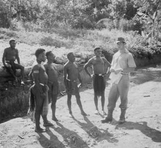 Paul Ryan’s article on the forest assessment of the Jimi Valley brought back some fond memories. This photograph will give readers some idea of the stature of the Jimis. Paul would have been about six feet in boots.
The Jimi Valley had never been mapped so, prior to our recce, a map had to be produced. The Dept of Forests had custody of the TPNG aerial photograph library which was made up of some modern photography, a lot of wartime mission photos, plus bits and pieces from other sources. From these aerial photos, using what would now be called primitive photogrammetric methods, the first detailed map of the Jimi Valley was prepared. I don’t know if the Forestry Dept still maintains a mapping section but I think not. The need to assess forest resources led to the production of maps for many areas not previously mapped.